River town commitments to conservation
The Cold River is recognized and used as a significant community resource as a link with the past, a site for today's recreational interests, and a visible thread that holds a way of life together.
In the spring of 1998, as part of the Regional Environmental Planning Program, UVLSRPC staff met with local officials and interested citizens in each community to determine local priorities relative to resource conservation. At meetings in corridor communities Unity, Lempster, Acworth and Langdon, as well as watershed community Charlestown, a consistent theme was the importance of surface waters and related resources. Each community identified lakes, rivers and brooks, shorelines and floodplains, special features such as waterfalls and cascades and natural heritage sites, and other unique habitat areas as community priorities. Through a similar process conducted by Southwest Region Planning Commission in 1997, Walpole identified the protection of rivers, brook, and wetlands as conservation priorities.
In addition to working as a regional watershed group through the Cold River Local Advisory Committee, many of the watershed towns have made additional conservation commitments to the waterway.
acworth
The 1997 Acworth Comprehensive Master Plan reflects the strong representation of local history the River carries for today's residents. The Plan discusses the transition in the settlement pattern from a widely dispersed population farming the hilltops to villages growing up along the River:
The ColdRiver was recognized as a source of water power and was altered by the construction of several dams along its length, the principal dam being the one at South Acworth village. The dams transformed the previously natural river by the creation of mill ponds supporting a variety of small water-powered industries. This industrial use gave rise to further growth especially in the village of South Acworth.
The importance of this link with the past to today's residents is evident. Local historian Helen H. Frink has identified fifteen historic mill sites along the River. A meeting of Acworth officials and residents gathered in April 1998 to discuss priorities for heritage conservation identified the Acworth mill sites as one of several priorities related to the River.
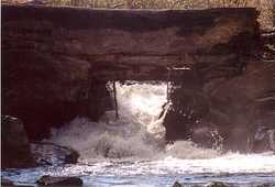
In addition to the reflection of the region's history provided by the River, the corridor is recognized by the Acworth community for the variety of resources associated with it. At a meeting held by Upper Valley Lake Sunapee Regional Planning Commission to discuss resource protection priorities of the Acworth community, several sites in the corridor were identified as priorities for protection including the wetland habitat associated with the River from East Acworth up into Lempster, the Dodge Brook fishery, the stone bridge over Honey Brook, the historic buildings of South Acworth, and Deep Hole with its scenic waterfall.
Acworth has taken steps to protect the scenic resources of the river corridor as well. Portions of four roads within the corridor are designated as scenic roads. As a result, certain special features of portions of Campbell Road, Ball Road, Grout Hill Road and Gates Mountain Road are subject to careful review prior to alteration.
The ColdRiver was recognized as a source of water power and was altered by the construction of several dams along its length, the principal dam being the one at South Acworth village. The dams transformed the previously natural river by the creation of mill ponds supporting a variety of small water-powered industries. This industrial use gave rise to further growth especially in the village of South Acworth.
The importance of this link with the past to today's residents is evident. Local historian Helen H. Frink has identified fifteen historic mill sites along the River. A meeting of Acworth officials and residents gathered in April 1998 to discuss priorities for heritage conservation identified the Acworth mill sites as one of several priorities related to the River.
In addition to the reflection of the region's history provided by the River, the corridor is recognized by the Acworth community for the variety of resources associated with it. At a meeting held by Upper Valley Lake Sunapee Regional Planning Commission to discuss resource protection priorities of the Acworth community, several sites in the corridor were identified as priorities for protection including the wetland habitat associated with the River from East Acworth up into Lempster, the Dodge Brook fishery, the stone bridge over Honey Brook, the historic buildings of South Acworth, and Deep Hole with its scenic waterfall.
Acworth has taken steps to protect the scenic resources of the river corridor as well. Portions of four roads within the corridor are designated as scenic roads. As a result, certain special features of portions of Campbell Road, Ball Road, Grout Hill Road and Gates Mountain Road are subject to careful review prior to alteration.
alstead
|
The importance of water resources such as the Cold River to the Alstead community is reflected in the development and adoption of a Water Resources Management and Protection Plan by the Planning Board in 1994. The Plan stresses the multi-town nature of surface and groundwater quality protection needs. Recommendations for action include acquiring aquifer lands and other sensitive water resource areas, development of a public education and monitoring program, developing wetland protection and scenic road ordinances, encouraging clustering to minimize the negative impacts associated with development, and developing a comprehensive regulatory program to protect the town's water resources.
|
|
lempster
The 1987 Lempster Master Plan reflects the community's strong feelings about the importance of the town's watercourses. after listing the Cold River as one of the watercourses particularly important to the community, the Plan goes on to state:
It is extremely important from both a local and a regional perspective that these rivers and brooks be kept clean and uninterrupted. In addition to their importance as a water supply and as a natural drainage system, they are vital to a variety of wildlife species and offer numerous recreational opportunities. Town residents, hunters, fishermen, environmentalists and even businessmen who want to capture the tourist's dollar all have a stake in the quality of Lempster's waters. the water resources of Lempster are an asset which should not be abused.
The Cold River through Keyes Hollow is discussed further as an important natural area providing important wildlife and fish habitat along with the associated recreational opportunities.
walpole
River protection planning has been in the forefront in Walpole for some time. The 1986 Master Plan recommends preserving the town's water resources, in part by discouraging development in wetlands, on steep slopes where erosion and sedimentation of water courses might occur, and in floodplains.
The Walpole Planning Board has been developing a natural features analysis to incorporate in the town's Master Plan. One goal of the analysis, currently in draft form, is the protection of scenic elements of the Town's natural environment, with an emphasis on areas adjacent to the Connecticut River and Cold River.
The Walpole Planning Board has been developing a natural features analysis to incorporate in the town's Master Plan. One goal of the analysis, currently in draft form, is the protection of scenic elements of the Town's natural environment, with an emphasis on areas adjacent to the Connecticut River and Cold River.
