Surficial Geology
As impressive as continental glaciation was to the land surface of the Cold River Corridor, the departure of these glaciers left the rich surficial geology we are familiar with today.
Glacial Lake Hitchcock, meltwater trapped behind an ice and rock dam near Middletown, Connecticut, stretched north to Lyme, New Hampshire, leaving evidence of its existence in the Cold River Valley. Melt water first flowing from (and on) the glaciers and eventually flowing down the Cold River valley deposited vast amounts of sand and gravel at the lake margin. Driving east on Route 123 towards Drewsville is an extensive plain with several small hills, including Drew Mountain, punctuating it. This was the top of a delta extending back to Cock Hat Hill, east of Alstead, that formed in glacial Lake Hitchcock over 10,000 years ago.
Glacial Lake Hitchcock, meltwater trapped behind an ice and rock dam near Middletown, Connecticut, stretched north to Lyme, New Hampshire, leaving evidence of its existence in the Cold River Valley. Melt water first flowing from (and on) the glaciers and eventually flowing down the Cold River valley deposited vast amounts of sand and gravel at the lake margin. Driving east on Route 123 towards Drewsville is an extensive plain with several small hills, including Drew Mountain, punctuating it. This was the top of a delta extending back to Cock Hat Hill, east of Alstead, that formed in glacial Lake Hitchcock over 10,000 years ago.
|
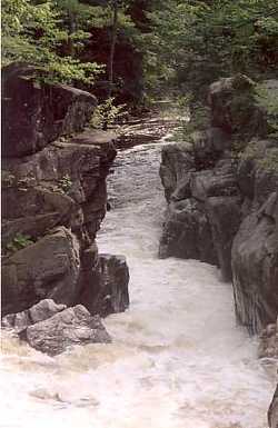
The Cold River now bisects the remnants of that delta, and terraces on either side of the River are evidence that the top of the ancient delta lay at a relatively consistent elevation of 492 feet. Within this great deposit is Drewsville Gorge, where the Cold River eroded the delta down to expose the bedrock.
Over the course of deglaciation, several small glacial lakes formed along the Cold River. One was behind the falls at Vilas Pool; the falls area was probably plugged by ice and sediment. This area and other former glacial lakes like it are interesting meltwater deposits of sand and gravel. Most are relatively intact having been exposed to only minimal mining. |
|
Just south of Vilas Pool is Cock Hat Hill. By following a woods road that leads along the west side of the hill along a trickle of a brook, there is an area with many glacial potholes. This area is well away and above the River channel. During deglaciation torrents of meltwater from Warren Brook must have roared through here. As the Cold eroded deeper into the surrounding sediments it captured Warren Brook's flow and the gorge around Cock Hat Hill was left dry.
