Bedrock Geology and Local Examples
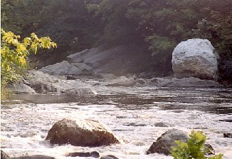
During the Ordovician Period, 430 - 500 million years ago, New Hampshire may have laid under the sea, bounded to the west by an ancient continental predecessor of North America, and bounded on the east by a volcanic island arc. Some of that period’s volcanism occurred under the sea and is now evident in the Ammonoosuc Volcanics. Such rocks are found in exposures between Alstead and South Acworth at Osgood Ledge, west of the Cold River.
Following this period of volcanic activity, sediments eroding from lands to the east buried the igneous rock under beds of mud. The rock from this period metamorphosed into schist known as the Partridge Formation. Towards the end of the Ordovician Period, the Taconic Orogeny occurred. With much folding and faulting, this mountain building event lifted the region of New Hampshire from under the sea. In the area of the Connecticut River, an upward arching structure formed as magma rose beneath the ground surface to form the Bronson Hill anticlinorium. Following this period of upheaval, erosion removed much of the Partridge Formation. What remains of this formation is also located between Alstead and South Acworth, although no good exposures have been located.
Following this period of volcanic activity, sediments eroding from lands to the east buried the igneous rock under beds of mud. The rock from this period metamorphosed into schist known as the Partridge Formation. Towards the end of the Ordovician Period, the Taconic Orogeny occurred. With much folding and faulting, this mountain building event lifted the region of New Hampshire from under the sea. In the area of the Connecticut River, an upward arching structure formed as magma rose beneath the ground surface to form the Bronson Hill anticlinorium. Following this period of upheaval, erosion removed much of the Partridge Formation. What remains of this formation is also located between Alstead and South Acworth, although no good exposures have been located.
As the land subsided, the sea again covered western New Hampshire, depositing quartz sands and gravels in a relatively thin layer many feet thick. These sediments eventually became Clough quartzite, present now in a narrow band between the older Partridge Formation and the younger Littleton Formation. A juncture where these three rock types are in close proximity to one another is at the mine on the side of Beryl Mountain.
The Littleton Formation that formed nearly 400 million years ago during the Devonian Period is composed chiefly of fine to sandy muds, now metamorphosed into schists. Sporadic volcanism is also evident from this time, and lies about one half mile from the river mouth, under many yards of sand and sediment. Rock representing the Littleton Formation is visible at Deep Hole in South Acworth and at Vilas Pool in Alstead.
About 385 million years ago the sea once again retreated and a period of folding began which coincided with the injection of masses of molten rock in the shape of great mushrooms into the region of the Ammonoosuc Volcanics. These cooled and consolidated into the Olivarian magma series. One of these granite structures bisects the Cold River just west of Beryl Mountain and is called the Alstead Dome. At a later stage, magma was injected into the Littleton Formation. It cooled and formed Bethlehem gneiss, part of the New Hampshire magma series and visible in two areas along the River. First, the Bellows Falls Pluton reaches from Alstead south to the Connecticut River and is visible at Drewsville Gorge. Second, stretching upstream from Honey Brook to Crescent Lake is the Mt. Clough Pluton, exposed near Honey Brook where ledge bisects the Cold River.
Since this last episode of folding and magma intrusions about 30 million years ago, erosion has been the dominant force in the Cold River Corridor, although it is likely that episodes of uplift alternated with periods of erosion many times in the last 25 million years.
Along with the Ammonoosuc Volcanics at Osgood Ledge, the Clough quartzite, Partridge Formation and Littleton Formation juncture at Beryl Mountain, the Littleton Formation exposures at Deep Hole and Vilas Pool, the Alstead Dome just west of Beryl Mountain, the Bellows Falls Pluton at Drewsville Gorge, and the Mt. Clough Pluton at Honey Brook, are the amazing pegmatites in this area. Pegmatite is an extremely coarse-grained granite formed during the same period as the New Hampshire magma series as a watery fluid injected into rock fractures. Because of their formation process, pegmatites are found in almost any rock type. Extremely large crystals form due to the watery nature of the material. Gene Boudette, NH State Geologist, conveyed that this mineralization resulted in a valley noted for its beryl and feldspar deposits. Beryl Mountain, just south of South Acworth, was the site of a large pegmatite mining operation. Beryl crystals four feet long and feldspar crystals fourteen feet long have been found. Other valuable minerals associated with pegmatites are quartz, and books of white mica. Three other mines once operated in the South Acworth area and extracted primarily feldspar, which was shipped to the Midwest for use in the glass and ceramics industries. These features make the Cold River Corridor a geologist's and rock hound's delight.
Along with the Ammonoosuc Volcanics at Osgood Ledge, the Clough quartzite, Partridge Formation and Littleton Formation juncture at Beryl Mountain, the Littleton Formation exposures at Deep Hole and Vilas Pool, the Alstead Dome just west of Beryl Mountain, the Bellows Falls Pluton at Drewsville Gorge, and the Mt. Clough Pluton at Honey Brook, are the amazing pegmatites in this area. Pegmatite is an extremely coarse-grained granite formed during the same period as the New Hampshire magma series as a watery fluid injected into rock fractures. Because of their formation process, pegmatites are found in almost any rock type. Extremely large crystals form due to the watery nature of the material. Gene Boudette, NH State Geologist, conveyed that this mineralization resulted in a valley noted for its beryl and feldspar deposits. Beryl Mountain, just south of South Acworth, was the site of a large pegmatite mining operation. Beryl crystals four feet long and feldspar crystals fourteen feet long have been found. Other valuable minerals associated with pegmatites are quartz, and books of white mica. Three other mines once operated in the South Acworth area and extracted primarily feldspar, which was shipped to the Midwest for use in the glass and ceramics industries. These features make the Cold River Corridor a geologist's and rock hound's delight.
